Friends of volcanic Legacy Scenic byway in Mt. shasta
We are members of the Mt. Shasta community who value the impressive scenic qualities our valley provides. As such, we support the Volcanic Legacy Scenic Byway's purpose of protecting scenic views from Interstate-5.
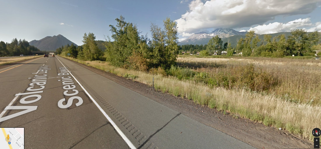
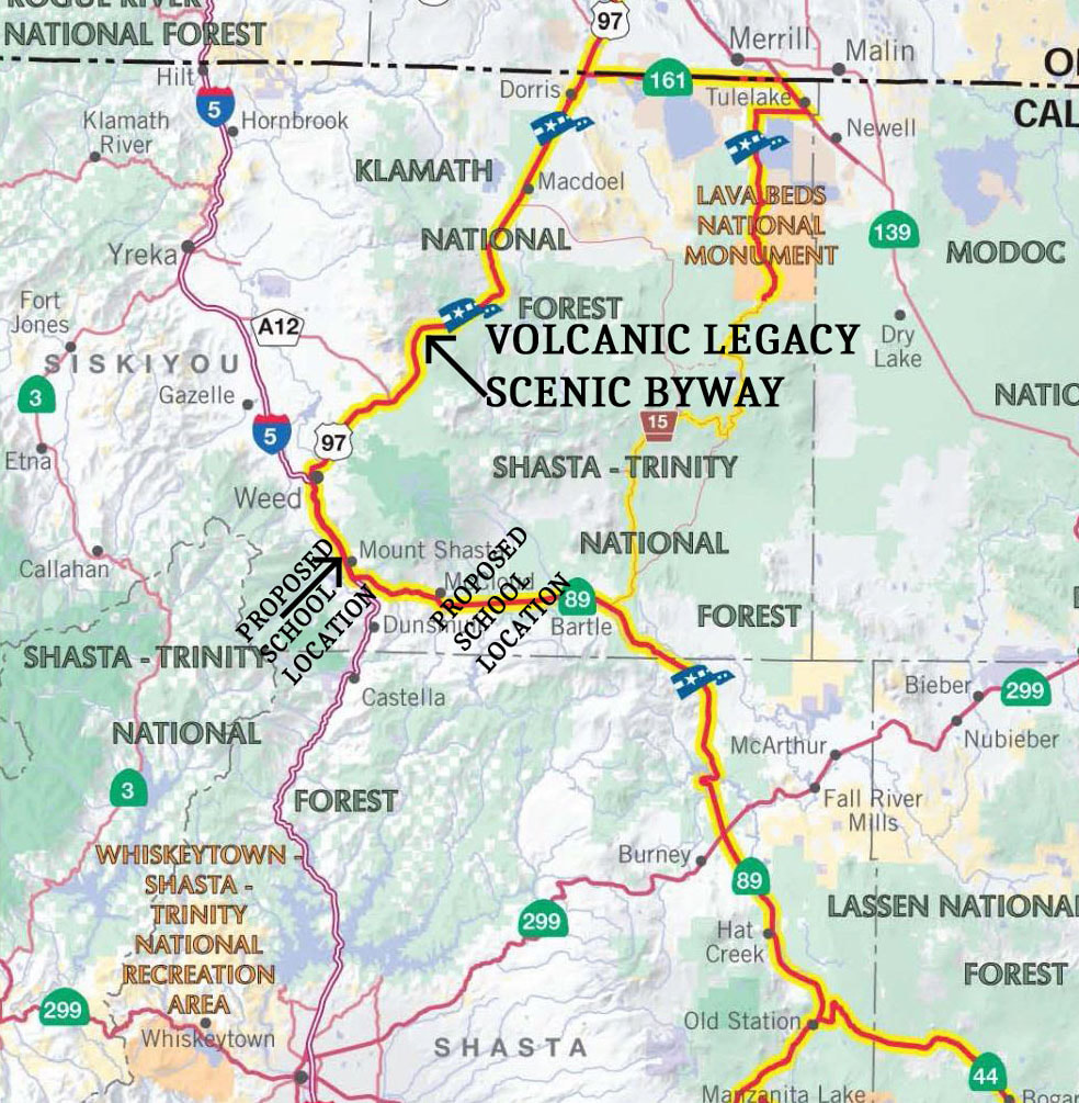
This Project would be within the 500-mile Volcanic Legacy Scenic Byway (VLSB). The byway received federal designation as a National Scenic Byway and All American Road in 2002 (California section). It is one of only 31 All American Roads in the United States with this distinction. This magnificent scenic drive winds its way from Crater Lake National Park in Oregon, through Lava Beds National Monument to Lassen Volcanic National Park and Lake Almanor in northeastern California.
To receive an All American Road designation, a highway must possess multiple intrinsic qualities that are nationally significant and contain one-of-a-kind features that do not exist elsewhere. The road or highway must also be considered a “destination unto itself.” That is, it must provide an exceptional traveling experience so recognized by travelers that they would make a drive along the highway a primary reason for their trip (Federal Register, May 18, 1995). The VLSB achieved national recognition because it met all six required “intrinsic qualities” for National Scenic Byway All American Road designation. These qualities include scenic, natural, cultural, historic, recreational, and archaeological. In the Mount Shasta area, the VLSB follows Interstate 5 (I-5) from State Route 89 near Mt. Shasta City to State Route (SR) 97 in Weed. This area has some of the most impressive geologic features along the byway—Black Butte, the Mount Shasta volcanoes to the east, and the high lakes country around Mt. Eddy to the west. Outdoor recreation and tourism are significant economic drivers in Mt. Shasta City.
The National Scenic Byways Program is administered by the Federal Highway Administration under policy issued in the Federal Register, May 18, 1995. This policy states: “Any road nominated for the National Scenic Byway or All-American Road designation will be considered to be a designated State scenic byway.” Upon federal designation as a National Scenic Byway All American Road in 2002, the VLSB also became eligible to be designated a California Scenic Highway. The Federal Register also clarified: “Moreover, the terms State Scenic Byway, National Scenic Byway, or All American Road refer not only to the road or highway itself but also to the corridor through which it passes.” In the Federal Register, “Corridor means the road or highway right-of-way and the adjacent area that is visible from and extending along the highway. The distance the corridor extends from the highway could vary with the different intrinsic qualities.”
The VLSB in California falls under the California Streets and Highways Code, Chapter 2, Division 1, Section 260 which states: “It is the intent of the Legislature in designating certain portions of the state highway system as state scenic highways to establish the State's responsibility for the protection and enhancement of California's natural scenic beauty by identifying those portions of the state highway system which, together with the adjacent scenic corridors, require special scenic conservation treatment.
263. The state scenic highway system is hereby established and shall be composed of the highways specified in this article. The highways listed in Sections 263.1 to 263.8, inclusive, are either eligible for designation as state scenic highways or have been so designated.
263.3. The state scenic highway system shall also include:
Route 5 from:
(f) Route 89 near Mt. Shasta to Route 97 near Weed.”
The Initial Environmental Study’s (IS/MND) analysis regarding the Golden Eagle Charter School project’s impact on this byway’s scenic corridor is incomplete relative to the above codes.
The proposed project is situated on the southwest flank of Mount Shasta, and the south flank of Black Butte. It is directly adjacent to I-5 where much of it will be prominently visible. Moreover, the school building will be visible to northbound motorists within the immediate foreground of a scenic view of Mount Shasta, one of the most iconic volcanoes in California and the Cascade Range.
The project is a stark contrast from the scenic vistas visitors expect to see here. The City’s conclusion in the Initial Study that there is “No Impact” on scenic resources and that impact on the existing visual character is “Less than Significant” is not supported by the analysis.
Some CEQA documents apply quantitative simulation models using measures for visual classes, size and scale, viewer sensitivity, distance zones, landform contrast, etc. However, these measures are no substitute for how people actually feel about visual intrusions. The impact on visual quality is a highly personal valuation. A good visual simulation model would also survey the people who live around Mt. Shasta and those who visit with the expectation of seeing views worthy of the byway’s designation. Ultimately, it is people’s perception of what constitutes a visual impact. Many people believe the proposed project’s aesthetic impact would fall in the “potentially significant” category.
The California Streets and Highways Code, Section 261, provides guidance for the protection of scenic highways and their adjacent corridors. “In the development of official scenic highways, the department shall give special attention both to the impact of the highway on the landscape and to the highway's visual appearance. The standards for official scenic highways shall also require that local governmental agencies have taken such action as may be necessary to protect the scenic appearance of the scenic corridor, the band of land generally adjacent to the highway right-of-way, including, but not limited to, (1) regulation of land use and intensity (density) of development; (2) detailed land and site planning; (3) control of outdoor advertising; (4) careful attention to and control of earthmoving and landscaping; and (5) the design and appearance of structures and equipment.”
The IS/MND fails to describe that the County’s General Plan Scenic Highways Element (adopted in 1975) identifies I-5 from SR 89 south of Mt. Shasta to SR 97 in Weed as a Scenic Freeway. The General Plan Scenic Highways Element states: “The Scenic Route Element is intended to provide for the preservation of scenic highways for the enjoyment of the general public . . .” (p. 2). It further states: Scenic Corridors are areas that extend beyond the Scenic Route right-of-way to which development controls should be applied for purposes of preserving and enhancing nearby views or maintaining unobstructed distant views along the scenic routes” (p. 5). “Widths of Scenic Corridors may vary from the depths of adjacent lots in urban areas to one or more miles in agricultural and forest lands. Within these corridors, controls should be developed to restrict unsightly use of the land, control height of the structures, control signs and billboards, and provide site and architectural guidance along the entire Scenic Corridor” (pp. 5-6).
